Our Projects

Real-world geospatial solutions delivered to government agencies across British Columbia. Each project demonstrates our commitment to accuracy, compliance, and measurable impact.

District of North Saanich

LiDAR Data Processing & DEM Generation
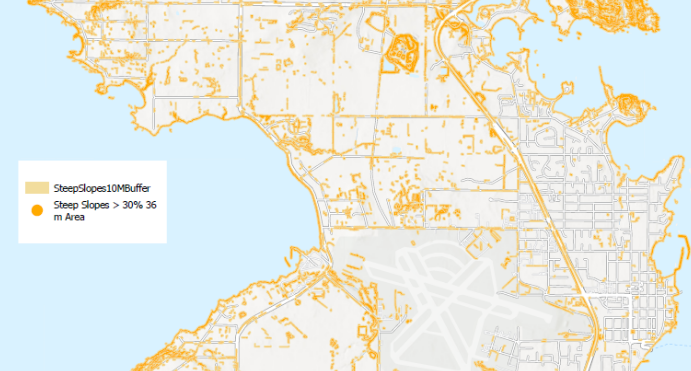
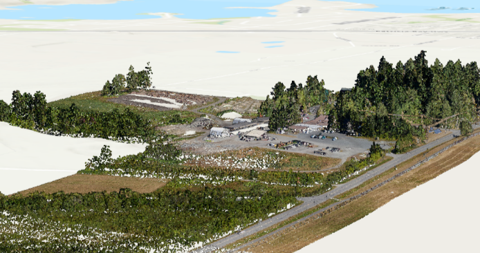
The District of North Saanich required comprehensive processing of raw LiDAR data for terrain analysis and infrastructure planning. We executed a complete data pipeline including advanced noise filtering, automated ground/non-ground classification, and rigorous quality assurance. The resulting high-resolution digital elevation model was validated for accuracy and delivered with full documentation for immediate use in planning workflows.

This project demonstrated the importance of methodical data processing—each step was documented, validated, and verified against ground-truth measurements to ensure government-grade accuracy.

Outcomes & Impact

Highly accurate DEM for terrain analysis
Validated against ground-truth surveys
Infrastructure planning datasets
Environmental management capabilities
LiDARDEM/DSMData ProcessingQA/QC
District of North Saanich

Steep Slope Map Production

Following DEM generation, the District required detailed slope analysis and risk classification mapping for land-use planning and hazard assessment. We computed slope gradients from the DEM, classified terrain into categorical risk bands, and produced professional cartographic outputs in multiple formats. The resulting maps integrate seamlessly into existing planning documents and support informed decision-making for development constraints.

The project showcased how geospatial analysis translates raw elevation data into actionable intelligence for municipal planning.

Outcomes & Impact

Slope classification for risk assessment
PDF, GeoTIFF, and Shapefile outputs
Land-use planning integration
Development constraint documentation
Slope AnalysisCartographyRisk ClassificationGIS
Columbia Shuswap Regional District

NG9-1-1 Addressing Data Aggregation

The Columbia Shuswap Regional District needed to consolidate addressing data across multiple jurisdictions for NG9-1-1 emergency response readiness. We designed and implemented an automated aggregation system that pulls from disparate sources, applies SSAP-aligned standardization, and enforces rigorous QA/QC rules. The solution tracks changes across versions and provides controlled staging for validation before delivery.

This project reduced manual coordination overhead by 70% and created a repeatable process for future data updates, ensuring compliance with NENA standards while maintaining data quality.

Outcomes & Impact

Centralized SSAP-aligned dataset
Automated QA/QC validation
Controlled staging & versioning
Validated, production-ready deliverables
NG9-1-1Data AggregationSSAPAutomationNENA
District of North Saanich

NG9-1-1 Readiness & Addressing Modernization

The District engaged Camber & Core to achieve full NG9-1-1 readiness with modernized addressing workflows. We built a purpose-designed web application that guides staff through addressing validation, automated conformance checking, and NENA-aligned standardization. The system continuously validates data integrity and generates audit logs for compliance documentation.

The result is a standardized, repeatable process that reduces errors, accelerates updates, and ensures the District maintains readiness for seamless emergency response system integration.

Outcomes & Impact

NENA standards compliance
Automated conformance validation
Web-based workflow application
Standardized, repeatable update process
NG9-1-1NENAWeb ApplicationValidationCompliance

Let's discuss your project

Whether you need LiDAR processing, NG9-1-1 readiness, or custom GIS solutions, we're ready to help.

Start a Conversation